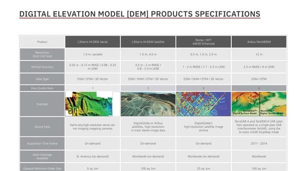
The applications of DEMs are diverse, and L3Harris Geospatial Data Solutions offers a wide variety of DEMs from multiple commercial sources. In addition, we can process new customized DEMs or derive 3D information to meet your application needs.
Selecting the right DEM for your application can be confusing because there are so many elevation products available, and they are generated from several data collection and processing technologies. This series of blogs will help you understand the differences in DEM products and capture technologies, as well as the relative advantages and disadvantages each delivers to specific end use applications.
What are DEMs?
A DEM data set defines points or grid cells with three values, or coordinates, – x, y and z - where x and y are traditional latitude-longitude location references, and z represents the elevation or height of the point or cell. There are two types of DEMs – Digital Terrain Models (DTMs) and Digital Surface Models (DSMs).
The DTM is often called a bare-earth or ground-only elevation model because it includes x, y, z values only for the ground. Vegetation and building features have been digitally stripped from the DTM data set. The DSM, on the other hand, contains all elevations whether from the ground surface, vegetation, or manmade structures.
Because DTMs and DSMs contain different information, their end use applications vary greatly and will be covered in depth in the third blog of this series. Generally speaking, DTMs are used in engineering, construction, and hydrographic projects where the topography of the natural terrain is most important. DSMs, on the other hand, are utilized in 3D visualization, infrastructure management, line-of-sight, and obstruction mapping applications where knowing the height of any feature, manmade or natural, is critical for success.
DTMs and DSMs are typically defined by accuracy and grid cell density (or spatial resolution). Horizontal accuracy is usually described by either x, y RMSE or Circular Error (CE). Similarly, vertical accuracy is measured in either z RMSE or by Linear Error (LE).
For example, 1 m CE90 and 5 m LE90 mean there is a 90 percent confidence the DEM measurement coordinates are correct to within 1 and 5 meters, respectively, of their actual locations on the ground. It should be noted that horizontal and vertical accuracies for one data set are often different.
In much the same way that remotely sensed imagery is rated by spatial resolution, DEMs are defined by density of elevation measurements. Raster DEMs are characterized by grid cell size, for example, 1 m or 5 m cell size, while vector DEM products are identified by the point spacing or distance between points, i.e., 1 meter, 5 meter, etc. (It should also be noted the term ‘resolution’ is often applied to DEMs and used interchangeably with ‘density’.)


